- Home
- Catalog
- Military Satellites & Space Systems
- China Jilin-1 Satellite
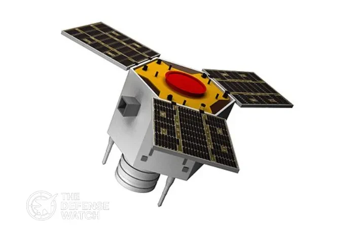
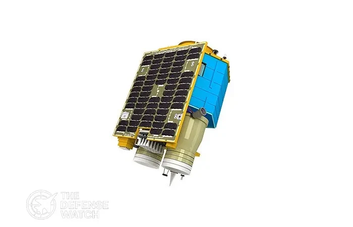
China Jilin-1 Satellite
Full Specifications
1. General Information
| System Name | Jilin-1 Earth Observation Satellite Constellation |
| Manufacturer | Chang Guang Satellite Technology |
| Country of Origin | China |
| Type / Role | Earth Observation / ISR Satellite |
| In Service | Yes |
| Year Introduced | 2015 |
| Unit Cost | USD 5–15 Million (Estimated per Satellite) |
2. Performance & Capabilities
| Orbit Type | Low Earth Orbit (LEO) |
| Operational Altitude | 500–650 km |
| Operational Inclination | Sun-Synchronous Orbit |
| Imaging / Sensor Type | Optical / Video Imaging |
| Resolution / Accuracy | Sub-meter resolution (variant dependent) |
| Revisit Time / Coverage | Multiple passes per day with constellation |
| Mission Duration | 5–7 years |
3. Payload & Sensor Specifications
| Primary Sensor | Optical Telescope Imaging System |
| Secondary Sensor | Multi-Spectral Camera |
| Data Transmission | Encrypted Satellite Communication |
| Imaging Capability | Daylight imaging, video observation |
| Payload Weight | 200–400 kg |
| Onboard Power | Solar arrays, approx. 1–2 kW |
4. Guidance, Control & Communication
| Attitude Control System | Reaction Wheels and Star Trackers |
| Orbit Control | Chemical propulsion micro-thrusters |
| Communication Link | X-Band / Ka-Band |
| Data Encryption | Military-grade encryption |
| Telemetry & Command System | Ground station control network |
5. Launch & Deployment
| Launch Vehicle | Long March 2D / Long March 6 |
| Launch Site | Taiyuan Satellite Launch Center |
| Deployment Orbit | Sun-Synchronous LEO |
| Launch Mass | 200–450 kg |
| Deployment Method | Rocket launch with multi-satellite deployment |
6. Operational & Command Use
| Primary Operators | Chang Guang Satellite Technology / China |
| Global Coverage | Yes |
| Combat Proven | Not officially confirmed |
| Typical Missions | Earth observation, maritime monitoring, ISR support |
| Notable Feature | Ability to capture high-definition video from orbit |
7. Future & Experimental Use
| Planned Upgrades | Higher resolution sensors and AI image processing |
| Replacement / Next Gen | Expanded Jilin-1 constellation |
| Experimental Variants | Real-time video satellites |
| International Collaboration | Limited commercial data partnerships |
PROS
- Large constellation improves revisit frequency
- Lower cost compared to traditional ISR satellites
- High resolution optical imaging capability
- Some satellites support video surveillance from orbit
- Useful for both civilian and military monitoring
CONS
- Limited resolution compared to classified military satellites
- Heavy reliance on ground station network
- Weather and cloud cover can affect optical imaging
- Data latency depends on satellite pass and downlink availability
- Vulnerable to electronic warfare or anti-satellite threats
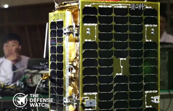
Jilin-1 Satellite Constellation ISR System
The Jilin-1 satellite constellation is one of China’s fastest growing commercial Earth observation networks, designed to provide high-resolution imagery, real-time video, and rapid revisit intelligence from space. Developed to support both civilian and defense applications, the system enables persistent monitoring of global activity from Low Earth Orbit.
Unlike traditional single reconnaissance satellites, Jilin-1 operates as a constellation of dozens of small satellites working together. This approach allows China to capture frequent imagery of strategic locations, maritime routes, and military infrastructure. With hundreds of satellites planned, the constellation aims to deliver near-continuous global coverage.
The satellites can capture detailed optical imagery and video of ground activities, which is useful for intelligence analysis, disaster monitoring, environmental tracking, and maritime surveillance. Analysts note that the system’s growing coverage provides China with a powerful ISR capability that can complement traditional military reconnaissance assets.
Manufacturer
The constellation is developed and operated by Chang Guang Satellite Technology Co., Ltd., a Chinese aerospace company based in Jilin Province. The company is supported by the Chinese Academy of Sciences and partners with national space organizations and commercial launch providers.
Speed and Range
Jilin-1 satellites operate in Low Earth Orbit at roughly 500–650 km altitude. Traveling at orbital speeds of about 7.5 km per second (around 27,000 km/h), each satellite circles Earth approximately every 90 minutes. The constellation design enables frequent revisit times, in some cases several passes per day over the same location.
Cost / Price
Exact pricing remains undisclosed, but industry estimates suggest USD 5–15 million per satellite, depending on sensor type and mission configuration. The lower cost compared to traditional reconnaissance satellites allows rapid expansion of the constellation.
FAQs
It provides high-resolution Earth observation imagery for intelligence, mapping, environmental monitoring, and maritime tracking.
The system is operated by Chang Guang Satellite Technology in China.
China has launched dozens of satellites, with long-term plans for more than 300.
Some variants provide imagery with resolution better than 1 meter.
Yes. Certain satellites in the constellation are capable of capturing high-definition video of ground activity.
Get real time update about this post category directly on your device, subscribe now.
Reviews
Disclaimer Note
The information provided on TheDefenseWatch.com is for general informational purposes only. While we strive to ensure the accuracy, completeness, and timeliness of our content regarding defense and aerospace products, technologies, and specifications, we cannot guarantee that all information is 100% accurate or up-to-date due to the evolving nature of military technology and classified data.TheDefenseWatch.com does not warrant the reliability, suitability, or availability of the information for any specific purpose. Users are advised to consult official sources, such as manufacturers, government publications, or defense agencies, for precise and verified data before making decisions based on our content.We are not affiliated with any defense manufacturers, governments, or military organizations mentioned. Opinions, reviews, and ratings reflect expert analysis but are subjective and should not be considered endorsements. TheDefenseWatch.com is not responsible for any errors, omissions, or consequences arising from the use of this website’s content.External links are provided for convenience and do not imply endorsement. TheDefenseWatch.com reserves the right to update or modify content without prior notice. By using this website, you agree to our Privacy & Cookies Policy.
New Arrivals


Popular Comparisons
-
 MQ-9 Reaper vs Bayraktar TB2 Comparison
View Comparison →
MQ-9 Reaper vs Bayraktar TB2 Comparison
View Comparison → -
KAI T-50 vs M-346 Trainer Aircraft Comparison
View Comparison →
-
HMS Dragon Type 45 Destroyer vs Arleigh Burke-class specs comparison
View Comparison →
-
BrahMos Missile System vs P 800 Oniks Missile, Key Differences Explained
View Comparison →
-
GCAP vs FCAS, Europe Sixth Generation Fighter Race
View Comparison →
-
Su-57 vs F-35 Cost Analysis: Price, Maintenance, and Export Availability
View Comparison →
-
SIG XM7 Rifle vs M4: Key Differences and Performance Comparison
View Comparison →
-
Eurofighter Typhoon vs Rafale vs F-35: Fighter Jet Comparison
View Comparison →
-
J-20 vs F-22: Stealth Fighter Showdown Explained
View Comparison →
-
F-14 Tomcat vs Su-57: Can a Legend Challenge Russia’s Stealth Fighter?
View Comparison →
- Saab Posts 23% Sales Surge In Q1 2026 As European Defense Demand Accelerates

- Finland Races To Hit 3.2% GDP Defense Target By 2030 Despite Sweeping Austerity Cuts
- Leidos Secures $617 Million Deal For U.S. Army IFPC Air Defense Launchers
- Mildef Unveils Mirsad 4×4 Vehicle To Expand Malaysia Infantry Mobility
- Malaysia Moves To Procure K-SAAM Missiles As Royal Navy Upgrades LMS Batch 2 Fleet
- China Selects Pakistani Astronaut Candidates For Space Station Mission As Strategic Space Ties Expand
- MQ-9 Reaper vs Bayraktar TB2 Payload Capacity, Which Armed Drone Carries More Firepower?
- Hypersonic Missile Speed vs. Ballistic Missile Defense: Can America’s Shield Hold?
- Space Force Completes GPS III Constellation To Counter Jamming And Spoofing Threats
- Lockheed Martin Secures $70.1M Deal For Romania F-35 Integration Program