

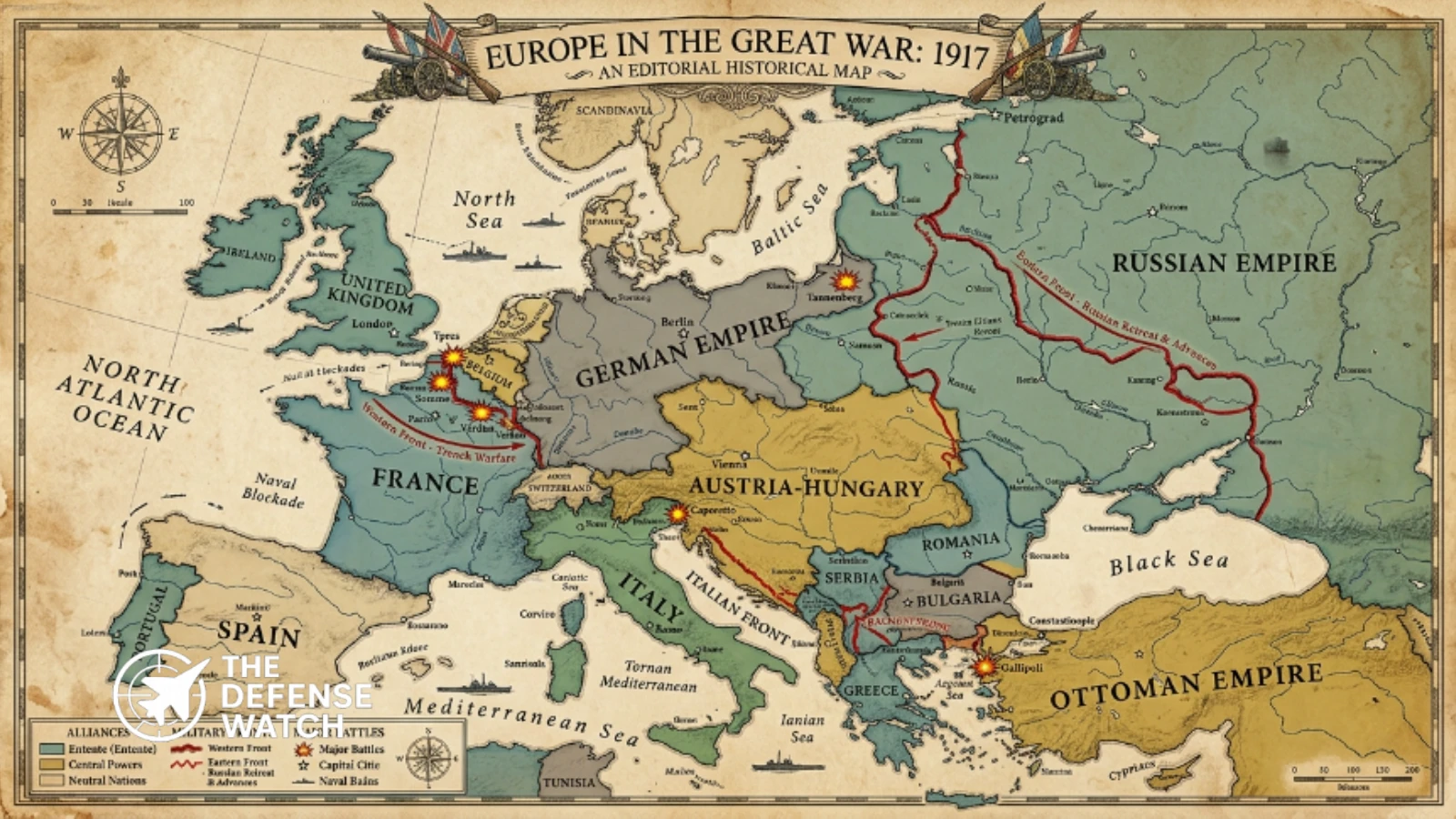
A WW1 map of Europe provides a visual explanation of how a regional crisis in the Balkans developed into a major European war and eventually a global conflict. In 1914, Europe was divided by complex political and military relationships, with Germany and Austria-Hungary forming the core of the Central Powers and France, Great Britain, and Russia forming the principal members of the opposing Entente coalition.
Takeaways
Key facts from the World War I map of Europe
1. Europe Was Divided by Rival Coalitions
Germany and Austria-Hungary formed the core of the Central Powers, while France, Great Britain, Russia, and later Italy and the United States were among the principal Allied powers.
2. Italy Did Not Enter the War With Germany
Although Italy belonged to the prewar Triple Alliance, it remained neutral in 1914 and entered the war against Austria-Hungary in 1915 alongside the Entente powers.
3. The Western Front Became a Trench-Warfare System
After the German advance was halted in 1914, the Western Front developed into an extensive system of trenches and fortified positions across Belgium and northern France.
4. Brest-Litovsk Changed the Eastern Front
The Treaty of Brest-Litovsk, signed on March 3, 1918, formally ended the war between Soviet Russia and the Central Powers and allowed Germany to redeploy forces toward the Western Front.
5. The Political Map Changed After the War
The German, Austro-Hungarian, Ottoman, and Russian imperial systems were fundamentally transformed or collapsed, producing major political and territorial changes across Europe and the Middle East.
The geography of the conflict changed repeatedly between 1914 and 1918. Major fronts developed across Belgium and France, Eastern Europe, the Italian Alps, the Balkans, and territories controlled by the Ottoman Empire. Fighting also extended into Africa, the Middle East, Asia, and the Pacific, making World War I a genuinely global conflict.
A World War 1 map of Europe therefore needs to be understood as more than a political map. It shows the relationship between national borders, alliances, military fronts, transportation routes, strategic geography, and the collapse of several major empires.
World War I Alliances Map
The alliance system was one of the most important factors shaping the geographic spread of the war.
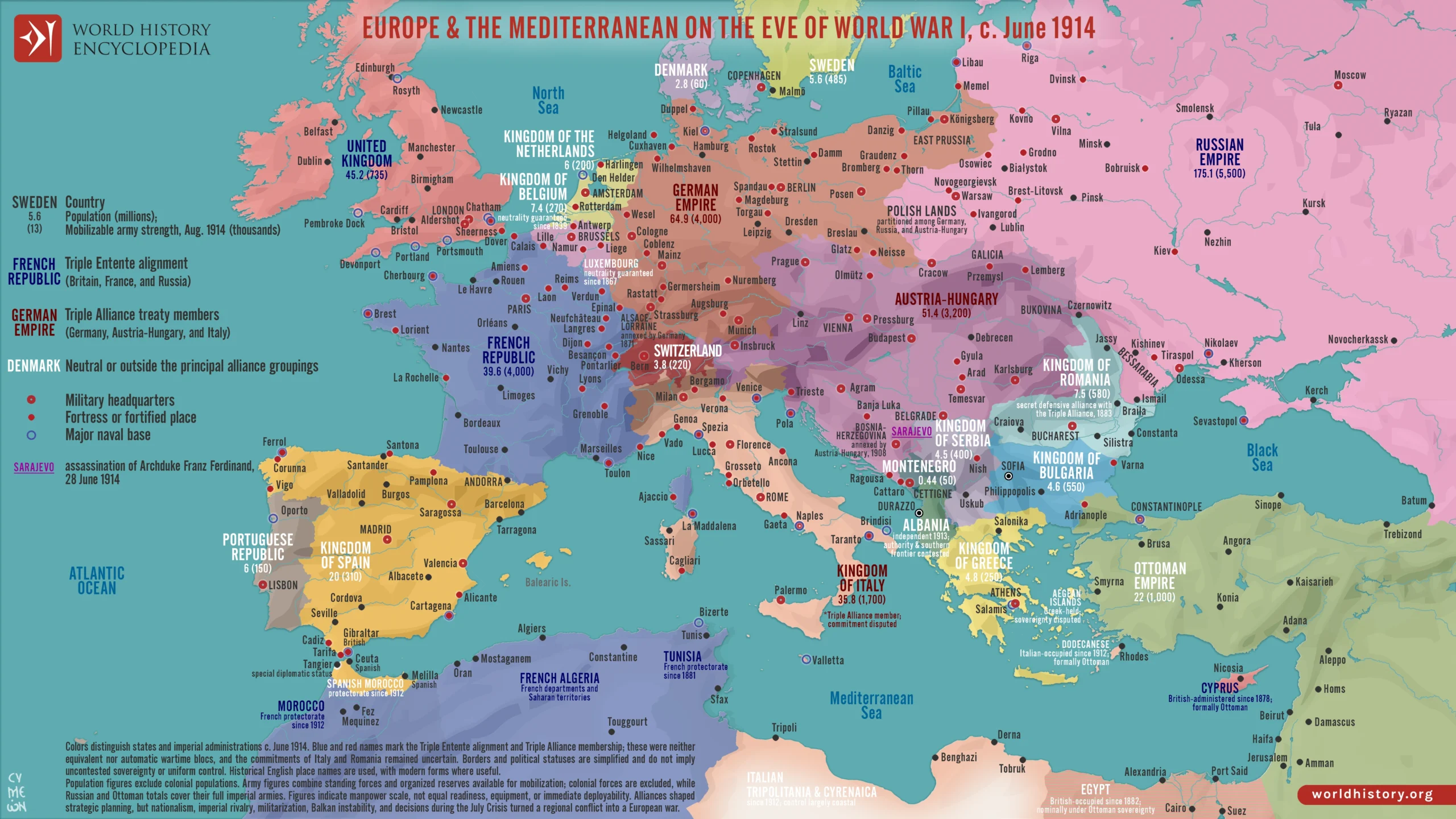
Before the conflict, Germany, Austria-Hungary, and Italy were members of the Triple Alliance. However, this did not mean that all three countries entered World War I on the same side.
Central Powers
The Central Powers developed around:
- Germany
- Austria-Hungary
- Ottoman Empire
- Bulgaria
Germany and Austria-Hungary were the principal Central Powers in the opening phase of the European conflict. The Ottoman Empire joined the war in late 1914, while Bulgaria entered the conflict in 1915.
Allied Powers
The Allied coalition developed around:
- France
- Great Britain
- Russia
- Serbia
- Belgium
- Italy
- Romania
- Greece
- United States
- Japan
- Other Allied and Associated states
The membership of the Allied coalition changed during the war as individual countries entered or left the conflict.
Italy’s Position in the Alliance System
Italy requires special attention when reading a World War 1 alliances map.
Italy was a member of the prewar Triple Alliance with Germany and Austria-Hungary, but it declared neutrality when war began in 1914. It later entered the conflict against Austria-Hungary after signing the Treaty of London with Britain, France, and Russia in April 1915. The agreement committed Italy to join the war alongside the Entente powers.
This distinction is important because a map showing the prewar alliance system and a map showing the wartime coalitions are not necessarily showing the same political arrangement.
Major Fronts on a WW1 Map
The major fronts of World War I developed in very different geographic environments. Their characteristics were influenced by terrain, transportation networks, military objectives, fortifications, and the availability of manpower and supplies.
Western Front
The Western Front became the best-known battlefield of World War I.
It stretched primarily through Belgium and northern France, where German forces confronted French, British, Belgian, and later American forces. After the initial German advance was stopped in 1914, the front developed into a heavily fortified system dominated by trenches, artillery, machine guns, barbed wire, and defensive positions.
The First Battle of the Marne in September 1914 prevented the German advance from achieving a rapid decision in France. The opposing armies subsequently established extensive trench systems extending from the North Sea toward the Swiss frontier.
The Western Front remained relatively stable geographically for much of the war, but this apparent lack of movement concealed enormous battles and casualties.
Major operations included:
- First Battle of the Marne
- Battle of Verdun
- Battle of the Somme
- Third Battle of Ypres
- German Spring Offensive
- Hundred Days Offensive
The Western Front illustrates how industrialized firepower made offensive operations extremely difficult when attacking prepared defensive positions.
Eastern Front
The Eastern Front covered a much larger geographic area than the Western Front.
German and Austro-Hungarian forces fought Russian armies across Eastern Europe. The front extended across areas that today include parts of Poland, the Baltic region, Ukraine, Belarus, and surrounding territories.
Unlike the Western Front, the Eastern Front remained considerably more mobile. Large distances, fewer continuous defensive systems, and the scale of the theater allowed armies to conduct major movements and retreats.
Russia’s military position deteriorated during the later stages of the war amid military losses, economic problems, political instability, and revolution.
The Bolshevik Revolution of 1917 fundamentally changed Russia’s participation in the war. Negotiations between Soviet Russia and the Central Powers resulted in the Treaty of Brest-Litovsk, signed on March 3, 1918. The agreement formally ended the war between Soviet Russia and the Central Powers. U.S. diplomatic records document the signing and subsequent ratification of the treaty in March 1918.
Russia’s withdrawal enabled Germany to redeploy forces from the Eastern Front toward the Western Front. This contributed to Germany’s ability to launch its major 1918 offensive in the west.
The strategic effect was significant, although the German offensive ultimately failed to achieve a decisive victory.
Italian Front
Italy entered World War I on the Allied side in 1915 and opened a new major front against Austria-Hungary.
The Italian Front developed largely along the mountainous border between Italy and Austria-Hungary. Fighting took place across the Alps and around the Isonzo River, where difficult terrain imposed severe limitations on movement and logistics.
Mountain warfare created different tactical problems from those found on the Western Front. Troops had to operate in high-altitude environments where weather, terrain, transportation, artillery positioning, and supply routes could determine the feasibility of military operations.
The Italian Front is therefore an important feature of a world war one map because it demonstrates how geography directly influenced military operations.
Balkan Front
The Balkans were central to the origins of World War I.
Austria-Hungary declared war on Serbia in July 1914 following the assassination of Archduke Franz Ferdinand and the subsequent diplomatic crisis. The fighting soon expanded as the major European powers became involved.
Serbia initially resisted Austro-Hungarian attacks, but the strategic situation changed after Bulgaria joined the Central Powers in 1915. Central Powers forces subsequently defeated Serbia and occupied much of its territory.
The Allies established a major military presence around Salonika in Greece. The resulting Macedonian Front remained active until 1918.
The Balkan theater demonstrates why a WW1 map of Europe cannot be understood simply through the Western and Eastern Fronts. Southeastern Europe was strategically important because of its location between Central Europe, the Mediterranean, the Ottoman Empire, and the Russian sphere.
Ottoman Fronts
The Ottoman Empire entered the war on the side of the Central Powers in 1914.
This expanded the geographic scope of the conflict considerably. Ottoman forces confronted Allied troops in several theaters, including:
- Gallipoli
- Mesopotamia
- Sinai and Palestine
- The Caucasus
- Arabian Peninsula
The Gallipoli campaign became one of the most important Allied operations against the Ottoman Empire. Allied forces attempted to force a route through the Dardanelles and gain access toward Constantinople, but the campaign ended with an Allied withdrawal.
Elsewhere, British and Allied forces fought Ottoman troops in Mesopotamia and Palestine. These operations contributed to the eventual collapse of Ottoman control over large parts of the Middle East.
World War 1 Map of Europe in 1914
A World War 1 map of Europe from 1914 looks substantially different from the political map of Europe today.
The German Empire occupied much of Central Europe, while Austria-Hungary controlled a large multinational empire stretching across Central and Southeastern Europe. The Russian Empire extended across Eastern Europe, while the Ottoman Empire still controlled important territory around the Balkans and the Middle East.
France and Germany shared a strategically important border, while Belgium occupied a critical position between Germany and France.
This geography was central to German military planning. Germany faced the possibility of a major war against both France in the west and Russia in the east.
The strategic problem of fighting on two major fronts influenced German planning throughout the conflict.
The Western Front and German Strategy
Germany’s geographic position created a difficult strategic problem.
France was located immediately to Germany’s west, while Russia’s enormous territory extended across the east. A prolonged simultaneous war against both powers risked dividing German military resources.
German planners therefore sought a rapid decision against France before concentrating greater forces against Russia.
The opening campaign in the west did not produce the expected decisive result. The German advance was halted during the First Battle of the Marne, after which the opposing forces established defensive positions extending across much of northern France and Belgium.
The result was a prolonged war of attrition.
How the Map Changed From 1914 to 1918
The political and military map changed considerably during the four years of fighting.
1914
The war began in Europe following the crisis between Austria-Hungary and Serbia. Germany declared war on Russia and France and invaded Belgium as part of its western campaign.
The German advance into France was stopped at the Marne, and the Western Front began to stabilize into a continuous trench system.
1915
Italy entered the war against Austria-Hungary.
Bulgaria joined the Central Powers, and the defeat of Serbia expanded Central Powers control in the Balkans.
The Gallipoli campaign also took place during this period.
1916
The Western Front saw major battles at Verdun and the Somme.
The Italian Front continued to consume large numbers of troops and resources, while fighting also continued across the Eastern and Ottoman theaters.
1917
The United States entered the war against Germany.
At the same time, Russia experienced two revolutions, eventually bringing the Bolsheviks to power.
The Russian military effort began moving toward withdrawal from the war.
1918
The Treaty of Brest-Litovsk was signed on March 3, formally ending the war between Soviet Russia and the Central Powers. The United States Office of the Historian records the treaty as part of the March 1918 diplomatic developments and identifies March 3 as the signing date.
Germany subsequently transferred substantial forces from the Eastern Front toward the Western Front.
Germany launched its major Spring Offensive in March 1918, initially achieving significant advances but ultimately failing to produce a decisive victory.
The Allies then launched a series of offensives that pushed German forces back.
The war ended with the Armistice of November 11, 1918.
The Political Map After World War I
The end of the fighting did not simply restore the prewar map.
Four major empires were fundamentally transformed or collapsed during and after the war:
- German Empire
- Austro-Hungarian Empire
- Ottoman Empire
- Russian Empire
New political arrangements emerged across Central and Eastern Europe.
The postwar settlement created or restored states including Poland, Czechoslovakia, and the Kingdom of Serbs, Croats and Slovenes, while the borders of existing states were also substantially changed.
The Treaty of Versailles and other postwar agreements attempted to establish a new political order.
The Treaty of Versailles later formally required Germany to accept the abrogation of the Brest-Litovsk treaties.
This means that a WW1 world map can represent several different moments: Europe before the war, Europe during the fighting, and Europe after the collapse of the old imperial system.
Why a World War I Map Matters
A map is particularly useful for understanding World War I because geography affected nearly every major strategic decision.
Germany’s central position created the danger of a two-front war. Belgium’s location made it strategically important to German operations against France. The Alps shaped the Italian Front, while the Balkans connected Central Europe to the Mediterranean and Ottoman territories.
Russia’s geographic depth created a very different operational environment from the Western Front. The Ottoman Empire’s location opened additional fronts in the Middle East and around the Dardanelles.
The war also demonstrated how modern industrial warfare could make relatively small changes in territorial control extremely costly.
A front line might move only a few miles while armies expended enormous quantities of ammunition, equipment, and manpower.
Reading a WW1 World Map
When examining a WW1 world map, readers should distinguish between several different types of information.
Political Borders
Political maps show the territory controlled by states and empires. These borders did not necessarily represent the exact position of military forces.
Military Fronts
Front lines show where opposing forces were engaged or where military positions were established. These could change rapidly during offensives.
Alliances
Alliance maps show political and military relationships. They should be dated because countries changed their position during the war.
Occupied Territories
Occupation does not necessarily mean that an area became part of the occupying country. Military occupation and permanent territorial sovereignty were different concepts.
Colonial Territories
European imperial powers also drew military resources from overseas territories. Troops from colonies and dominions participated in several theaters, helping make World War I a global conflict.
Strategic Assessment
The geography shown on a World War I map explains why the conflict became so difficult to resolve.
The Central Powers were positioned in the center of Europe and faced enemies on multiple fronts. The Allies, meanwhile, could draw on resources and manpower from several major powers and their overseas territories.
The war also exposed the limitations of prewar assumptions about rapid military campaigns. Industrial firepower, defensive fortifications, machine guns, artillery, barbed wire, and increasingly sophisticated logistics made decisive breakthroughs extremely difficult on several fronts.
The Eastern Front was more mobile than the Western Front, but its collapse did not produce the strategic result Germany needed. The Treaty of Brest-Litovsk allowed Germany to concentrate forces in the west, but the subsequent 1918 offensive failed to defeat the Allied armies before American manpower and material resources could have a decisive effect on the balance of the conflict.
The final map of Europe was therefore shaped by both military operations and political collapse. World War I destroyed or transformed several imperial systems and established political conditions that would influence European security for decades.
